(Reproducido de http://www.airfields-freeman.com/PR/Airfields_PR_W.html)
Vega Baja Auxiliary Airdrome, Vega Baja, PR
18.48 North / 66.43 West (West of San Juan, PR)

Vega Baja Airfield, as depicted on the May 1964 USAF Operational Navigation Chart (courtesy of Chris Kennedy). Photo of the airfield while open has not been located.A total of 554 acres was acquired by the Federal Government in 1941 to develop the Vega Baja Auxiliary Airdrome. The Army constructed a runway, taxiway, roads, utilities, and several buildings. The field was used as an auxiliary airfield to Ramey Airfield, and was used for training by units with P-36, P-39 & P-40 fighters, among others.
It was an active installation from 1941-1956, when its functions were no longer required. Between 1956-1975, the Puerto Rican National Guard utilized the property for training purposes.
A single runway at Vega Baja was still depicted on the May 1964 USAF Operational Navigation Chart (courtesy of Chris Kennedy), but it was labeled as «Abandoned».In 1976, the property was conveyed to the Commonwealth of Puerto Rico.

The 1977 USGS topo map depicted Vega Baja as having a single southwest/northwest runway, with multiple taxiways on the southeast side. Ricardo Medina reported in 2005, “Twenty five years ago the strip was used by apprentice drivers to practice for their license driving test (I was one of them) and at night on certain weekends it was used for illegal drag racing.”
A 1992 Army Corps of Engineers report stated that part of the site is currently used as a public park, and the remainder of the site is still undeveloped. The Vega Baja airfield property was used in 1992 by NASA to launch sounding rockets for atmospheric research.
The airfield has apparently never been reused for civilian aviation.
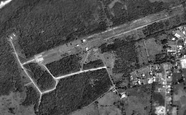
As seen in the 1995 USGS aerial photo, the airfield consisted of a single 4,000′ long paved runway, and a network of taxiways extending from the west end of the runway.
Several buildings had been placed over the runway’s middle section.
Vega Baja was depicted on the 1998 World Aeronautical Chart as an abandoned airfield.

A 2000 photo by Ricardo Medina of model airplanes on the runway at Vega Baja.

An October 30, 2004 USGS aerial view looking northeast at the site of the Vega Baja airfield, showing the model aircraft runway which has been overlaid on the west end of the former runway.
Ricardo Medina reported in 2005, “The airfield is still used as a airfield but ironically used by a model airplane association group that fly remote controlled aircrafts on weekends. In recent years, the airstrip was used on several occasions as drop-off place for drugs by cartel members, forcing the authorities to divide the airstrip in half by means of a cyclone fence to prevent its further use. Very few structures remain of that era, and the surrounding vicinity is being rapidly developed with residences.”

A 2012 photo by Paul Betancourt of Vega Baja, “Looking northwest to the end of the strip. It appears from some of the exposed areas that the original runway surface was mix of tar & crushed local rock & coral, like the ones the 20th Air Force would construct.”
Paul Betancourt reported in 2012 of the Vega Baja airfield, “I gained access from the Parks & Recreation Department for a tour of the easiest end of the field. The model airplane club has since been banned from the area for being problem residents.
As we saw & the superintendent pointed out, they weren’t treading lightly: there’s a whole lot of trash by the fence and I found stuff like broken tools. Particularly along the western access roads & the east half of the strip, it’s beginning to be reclaimed and looks similar to the strips on Bougainville, etc.
I did spend a good amount of time trying to find anything that the 22nd & 23rd Fighter Squadrons may have left behind with no results other than a sunburn. The end of the strip is beginning to be retaken by flamboyan trees, and the auxiliary roads to the main gate, radio tower, and launch site are turning to gravel. The taxi strip has become the park’s parking lot, and the one remaining structure is being maintained. The east end maintains the outline, but is almost completely overtaken by grass. The Parks & Recreation guy said that they want to commemorate the field somehow, but the east end will likely become a small wind farm.”

A 2012 photo by Paul Betancourt of Vega Baja, of “the one surviving structure, near where the entrance road meets the taxiway.”
